
x
Mapunity's flagship product for urban mobility is the Transport Information System (TIS) - a public information project which combines information for the public, with administrative tools for officials, and solutions for different business segments of mobility in cities.
Mapunity's TIS features
- Find locations and points of interest
- Find directions between locations
- Make local maps at high resolution showing the streets around any location (useful to put at bus stops, street corners, etc)
- Allow people to add their homes and offices to the map search
- Allow administrators to mark one-way streets, no-parking areas and other restrictions
- Allow users to request additional bus services in their neighbourhoods
- Allow users to report any problem related to mobility to the appropriate authorities
- Query bus, train, tram and other services in the city to any location
- Maintain a list of ongoing public works linked to mobility
- Find taxi services, app-based aggregators and other mobility solutions providers
- Mark key transit points (airport, stations, etc) and include specific information pertaining to these
- Show traffic camera feeds
- Show live traffic speeds if available
- List pay-and-park locations in the city, with fees, timings, etc. and also facilitate bookings
- List the toll locations in the region, along with fees
- Show all govt offices linked to mobility (traffic police, vehicle licensing dept. fine payment centres, etc)
- Query vehicle ownership records to facilitate genuine second sales
- Query fines against individual vehicles that are outstanding, and help clear these
- Maintain a list of punishable offences, and the fines for each
- Include safety information and campaigns run by the city for road safety
- A personal tracker tool that helps families know where everyone is.
- A passenger information system to let the public know where their buses are and when they will arrive at a stop
- An ambulance assistance program (also useful for other emergency vehicles) to help keep signals green along rescue paths
- An asset monitoring tool for all public assets
- A school bus tracking solution for educational institutions
- List of all application forms used by the government for services in the transport sector
- API-based submission of applications (if made possible by the departments)
- iOS and Android apps for all of these.
- Locations of fuel stations and public charging infra
- Locations of hospitals, along with one-click access from transport app for emergency services
- Locations of bicycle shops and rentals
- Alerting system for announcements and regular PR
- Integration with news feeds of news organisations in the city
- Bus routes management system (introduce, edit, delete) which is integrated with the passenger information system
- Accident hot-spot marking, and highlighting of accident prone locations
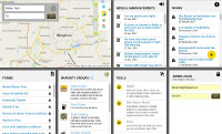
Example : Bengaluru (btis.in)

Personal tracker : for friends and family.

For schools : Let mTrac track your buses.

mSignal : Measure, manage traffic at lights.

O-D : local mobility in your neighbourhood.

BusCloud - application suite for city bus ops.
SignMaps - for last mile directions.